
When winter arrives in full force across the Great Lakes region, one phrase instantly grabs attention: lake effect snow warning Ohio. For residents of Northeast Ohio, especially those living near Lake Erie, this warning isn’t just another weather alert — it’s a sign that rapid snowfall, hazardous roads, and unpredictable conditions may be on the way. Understanding exactly what a lake effect snow warning means, how it forms, and how to prepare can make a huge difference in safety and day-to-day planning.
In this guide, you’ll learn everything you need to know about lake effect snow warnings in Ohio, including how they work, which areas are most affected, and what steps you can take to stay safe, informed, and ready for whatever winter brings.
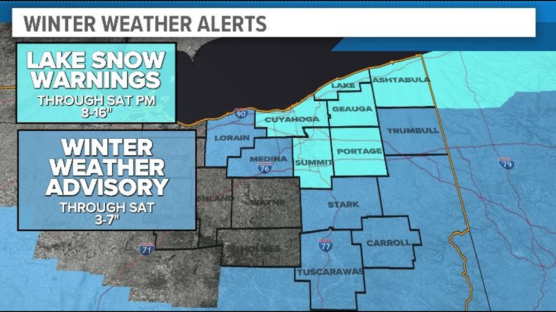
What Is a Lake Effect Snow Warning in Ohio?
A lake effect snow warning Ohio is issued by the National Weather Service (NWS) when meteorologists expect heavy, localized snowfall generated by cold air moving over the relatively warm waters of Lake Erie. This type of warning signifies intense snow bands capable of producing rapid accumulations within short periods.
Unlike general winter storm warnings, lake effect snow warnings are extremely localized. One town may get 12 inches while another, only miles away, sees nothing more than a few flurries.
The official NWS criteria vary slightly by region, but in Northeast Ohio, a lake effect snow warning typically indicates:
- 6–12+ inches of snow expected within 12 hours, or
- 8–18+ inches within 24 hours,
- Often accompanied by blowing snow and wind gusts reducing visibility.
These warnings help communities plan ahead, especially those in the “snow belt” areas east and southeast of Cleveland.
How Lake Effect Snow Forms Over Ohio
Lake effect snow occurs when cold Arctic air sweeps across the Great Lakes, absorbing moisture and heat from the water. When the air mass moves onto land — especially higher elevations — the moisture condenses and falls as snow.
The Steps Behind the Science
- Cold air flows over warm lake water
In early winter, Lake Erie retains heat from the previous season. Arctic air passing over the lake creates an unstable temperature contrast. - Moisture rises into the atmosphere
As the cold air picks up lake moisture, towering clouds form quickly. - Wind direction determines snow band placement
Strong, steady winds from the northwest or north push snow bands into Northeast Ohio. - Snow intensifies over the Snowbelt
Elevated terrain accelerates condensation, turning clouds into heavy snow bursts.
Because Lake Erie is the shallowest of the Great Lakes, it freezes faster — but before it does, it’s a perfect engine for intense snow events.
For readers wanting to explore weather science further, external resources like the National Weather Service (weather.gov) and NOAA.gov offer excellent detailed explanations.
Why Ohio Gets Hit So Hard
Many ask: Why is Northeast Ohio such a hotspot for lake effect snow?
The answer comes down to geography.
1. Proximity to Lake Erie
Northeast Ohio sits directly south of Lake Erie, positioned perfectly for snow bands to roll inland.
2. Elevation changes
The inland hills and ridges in counties like Geauga and Ashtabula enhance snowfall.
3. Prevailing wind patterns
Winter winds commonly blow over the length of Lake Erie, gathering moisture along the way.
4. Unpredictable band shifts
Lake effect snow is notorious for drifting unexpectedly. A slight wind shift can move a snow band miles within minutes — a major reason why the lake effect snow warning Ohio alerts are taken seriously by locals.
Counties Most Impacted by Lake Effect Snow
While all of northern Ohio can occasionally see lake effect snow, the highest snowfall totals typically occur in the primary Snowbelt and secondary Snowbelt regions.
Primary Snowbelt:
- Ashtabula County
- Geauga County
- Lake County
- Eastern Cuyahoga County
These areas regularly experience intense snow accumulation, sometimes measuring in feet rather than inches.
Secondary Snowbelt:
- Summit County
- Portage County
- Trumbull County
These regions are affected when winds blow from specific directions or when snow bands extend farther inland.
If you run a regional weather website, here is a perfect opportunity to add internal links to your “Ohio Snowbelt Guide” or “Best Winter Travel Routes in Ohio” pages.
What a Lake Effect Snow Warning Ohio Typically Includes
When the National Weather Service releases a lake effect snow warning, Ohio residents can expect crucial information, such as:
- Expected snowfall amounts
- Snow band locations
- Timing (start and end)
- Wind speed and direction
- Impacts to visibility
- Hazardous travel advisories
These warnings use highly localized forecasting, often breaking information down by township or zip code.
How Much Snow Can You Expect?
Lake effect snow totals vary dramatically depending on band placement. During a lake effect snow warning Ohio, snowfall rates of 2–4 inches per hour are common.
Some memorable lake effect events in Ohio produced:
- 30+ inches in 24 hours in parts of Geauga County
- Multiple feet of snow over several days during persistent band formation
- Travel-crippling whiteouts along I-90 and local highways
Lake effect snow is famous for its intensity, not its predictability. That’s why warnings are so essential.
How to Prepare for a Lake Effect Snow Warning
Preparation is the key to staying safe during any major weather event. When a lake effect snow warning Ohio is issued, use the following checklist to get ahead of the storm.
1. Prepare Your Home
- Stock up on food, water, and medications for at least 48–72 hours.
- Check heating systems and keep extra blankets or backup heat sources available.
- Protect pipes from freezing by insulating them or allowing a slow drip.
- Ensure snow shovels, ice melt, and roof rakes are ready to use.
2. Prepare Your Vehicle
- Fill your gas tank (a full tank reduces condensation and keeps the car warm if stranded).
- Carry a winter emergency kit with:
- Blanket
- Gloves
- Flashlight
- First-aid supplies
- Snacks
- Ice scraper
- Jumper cables
- Check tire tread and pressure; winter tires are ideal.
3. Stay Informed
- Follow NWS Cleveland on social media or via NOAA Weather Radio.
- Consider signing up for county-specific emergency alerts.
- Check local news websites or apps frequently.
For extra authority, an internal link to your site’s “Winter Safety Tips” article can add value here.
Travel Tips During Lake Effect Events
Driving in lake effect snow is particularly dangerous due to sudden low visibility and icy patches.
Here’s how to stay safe:
- Avoid unnecessary travel during peak snowfall.
- Reduce speed significantly — whiteouts can occur without warning.
- Keep headlights on low beam.
- Maintain extra distance between vehicles.
- Watch for snow squalls, which can drop visibility to near zero.
If you must travel, check ODOT’s real-time road conditions map (good external link suggestion).
School Closures & Community Impacts
Lake effect snow often disrupts:
- Schools
- Public transit
- Medical appointments
- Businesses
- Road construction and maintenance schedules
Districts in Geauga, Lake, and Ashtabula counties are particularly known for frequent closures. Anticipating these disruptions when a lake effect snow warning Ohio is issued helps families plan accordingly.
How Meteorologists Predict Lake Effect Snow
Forecasting lake effect snow is both an art and a science.
Meteorologists analyze:
- Wind direction and speed
- Temperature differences between lake water and upper air
- Lake surface temperature
- Atmospheric moisture
- Elevation patterns
The unpredictability of snow bands keeps forecasts challenging, but technology — including Doppler radar and advanced computer models — has improved warning accuracy significantly.
Long-Term Winter Safety Tips
As winters become more unpredictable, it’s wise to remain ready throughout the season.
Long-term tips include:
- Keep vehicles winter-ready from November through March.
- Refill rock salt and emergency supplies frequently.
- Have a backup plan for work, childcare, and travel.
- Stay educated about alerts such as Snow Squall Warnings and Winter Weather Advisories.
A lake effect snow warning Ohio may only last a day or two, but its impacts can linger far longer.
FAQ: Lake Effect Snow Warning Ohio
1. What triggers a lake effect snow warning in Ohio?
A warning is issued when heavy, localized snow — typically 6–12+ inches — is expected within a short timeframe due to lake effect processes.
2. How long do lake effect snow events usually last?
Events can last from several hours to several days depending on wind patterns and lake temperature.
3. Which areas in Ohio are hit hardest?
The primary Snowbelt — including Lake, Geauga, Ashtabula, and eastern Cuyahoga counties — often sees the heaviest snowfall.
4. How is lake effect snow different from regular snow?
It’s more localized, more intense, and dependent on lake conditions rather than large-scale weather systems.
5. How can I stay safe during a lake effect snow warning?
Prepare your home and car, stay updated with NWS alerts, avoid unnecessary travel, and keep emergency supplies ready.
Conclusion
A lake effect snow warning Ohio is more than just a weather alert — it’s a crucial heads-up that rapid, heavy snow and dangerous travel conditions may be imminent. By understanding how lake effect snow forms, which areas are most impacted, and how to prepare effectively, you can stay safe and confident throughout the winter season.
Whether you’re a lifelong Ohio resident or new to the Snowbelt, taking these warnings seriously ensures you’re ready for whatever Mother Nature sends across Lake Erie.